A guide to Churches and Graveyards in Surrey for family historians
|
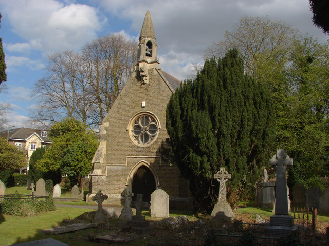
The mortuary chapel was consecrated in 1851 (https://www.british-history.ac.uk/vch/surrey/vol3/pp403-413#h3-0003 consulted December 2019) Friends of Surrey Cemeteries (Surrey Cemeteries: a survey, 2012): Eastworth Road A317. Small burial ground around chapel. New cemetery across lane which now forms entrance. Opened 1800 c ¼ acre. It is unclear why only central part of walled area around chapel is designated as the burial ground – it could be that it predates the chapel (quite possibly). SHC 5219/1/2 index of burials 1851-90. In date order within alpha – name, section, plot number, date of burial, observations. Visited 2005 - Chapel with bell tower and external bell and burial ground now forms part of Chertsey cemetery. Burial ground itself has been extended within walls without demarcation between original burial ground (except on map). Strong churchyard feel with many Yews and other mature trees. No sign of laying down in BG but cancer has spread to the main cemetery areas with many taped graves and some already laid down. Revisited. No changes to condition of ground. Still used as a walk-through by children from the school behind. West Surrey Family History Society has details of war graves which are in the new cemetery across the lane from the old St. Stephen's Burial Ground. St Stephen's Burial Ground is in the Ancient Parishan Ancient Parish is a Church of England parish which, until the 19th century, had both ecclesiastical and civil functions of Chertsey St. Peter There are around 550 names in the Surrey Monumental Inscriptions Index for St. Peter's church.
Search for any references to your ancestor in the Surrey Index of Names:
https://www.wsfhs.co.uk/pages/sindex/siSearch.php (opens in new browser window) or use our contact form if you have a question not answered in the Surrey Index of Names or in our Frequently Asked Questions https://surreychurches.org.uk/contact West Surrey Family History Society CD10 (The Surrey Burial Index - 2nd edition 2009) has burial records for:
WSFHS CD 26 Parish Register Transcripts and Indexes in the Chertsey District - January 2012) has baptismal records for Chertsey St. Peter from 1620 to 1840, and burial records from 1607 to 1840. For full details and a list of parishes covered see our sales page (opens in a new page). Chertsey is a town in the Runnymede District of Surrey
Unless otherwise stated the dates for the creation of parishes are taken from Youngs, Frederick. A. Guide to the Administrative Units of England; Royal Historical Society: London, 1979 volume 1 Southern England.
The Runnymede Index will show you all the churches and cemeteries we know of in the Runnymede District. If we have missed any or you are looking for a church or graveyard that might no longer exist do please let us know using the email at the bottom of this page If you came to this page from our main index to churchyards If you came from the Runnymede page use the button at the top of this page to close the page and go back to the Runnymede index. |
LinksCemeteries web siteWikipedia GEN UKI Page British History on line contact us: https://surreychurches.org.uk/contact |
